
I was having an outdoor lunch in Camarillo with the Ventura County Ninety-Nines the other day when a tourist walked up to us and asked, “Can you tell me how to get to In-N-Out Burger?” I told him:
Continue present heading until you hit the Factory Outlet Mall (FOM) zero four five radial.
The other pilots giggled while the tourist gave me the stink eye. Sheila quickly took pity on him:
It’s just one more exit down US-101.
We then watched the tourist drive out of the parking lot and turn the wrong way.
This kind of confusion happens between ATC and pilots all the time, and I think automation is making things worse.
You’ve heard it before: GPSes and moving maps increase situational awareness. Right? Phooey! Consider the following clearances.
“N12345, turn right Heading 070, intercept V25, resume own navigation.”
“N12345, after Salinas, track the Salinas 140 radial, expect vectors to final.”
“N12345, amend route to: fly heading 080, intercept the Santa Monica 135 Radial, Santa Catalina 350 Radial, Santa Catalina. Rest of route unchanged.”
In this day and age of electronic flight plans and moving maps, you would think these clearances would get easier to handle. They’re not; they’re getting more difficult. Why? Because automation doesn’t understand ICAO English, and pilots don’t have the same kind of situational awareness they had before.
What do all these clearances have in common beyond causing rapid hair loss? They all require interpretation by a pilot who knows his or her position relative to nearby VORs and ATS routes (airways), a pilot who knows where he or she is going.
Why is automation making this more difficult? Because pilots are delegating their awareness to the avionics. With a moving map, you can always immediately see where you are. That improves your positional awareness when you are looking at the moving map. But if you are not thinking about where you are, the awareness doesn’t stick.
In addition, with a lot of automation on board the aircraft, a pilot’s first thought in reaction to instructions from ATC is: how to program the automation. There is a strong tendency to skip thinking about what ATC’s instructions actually mean. I see this all the time with my recurrent training students.
How To React To ATC Instructions
This may seem overly rudimentary to many of you, but it bears repeating. When you receive instructions from ATC, you should respond in the following sequence:
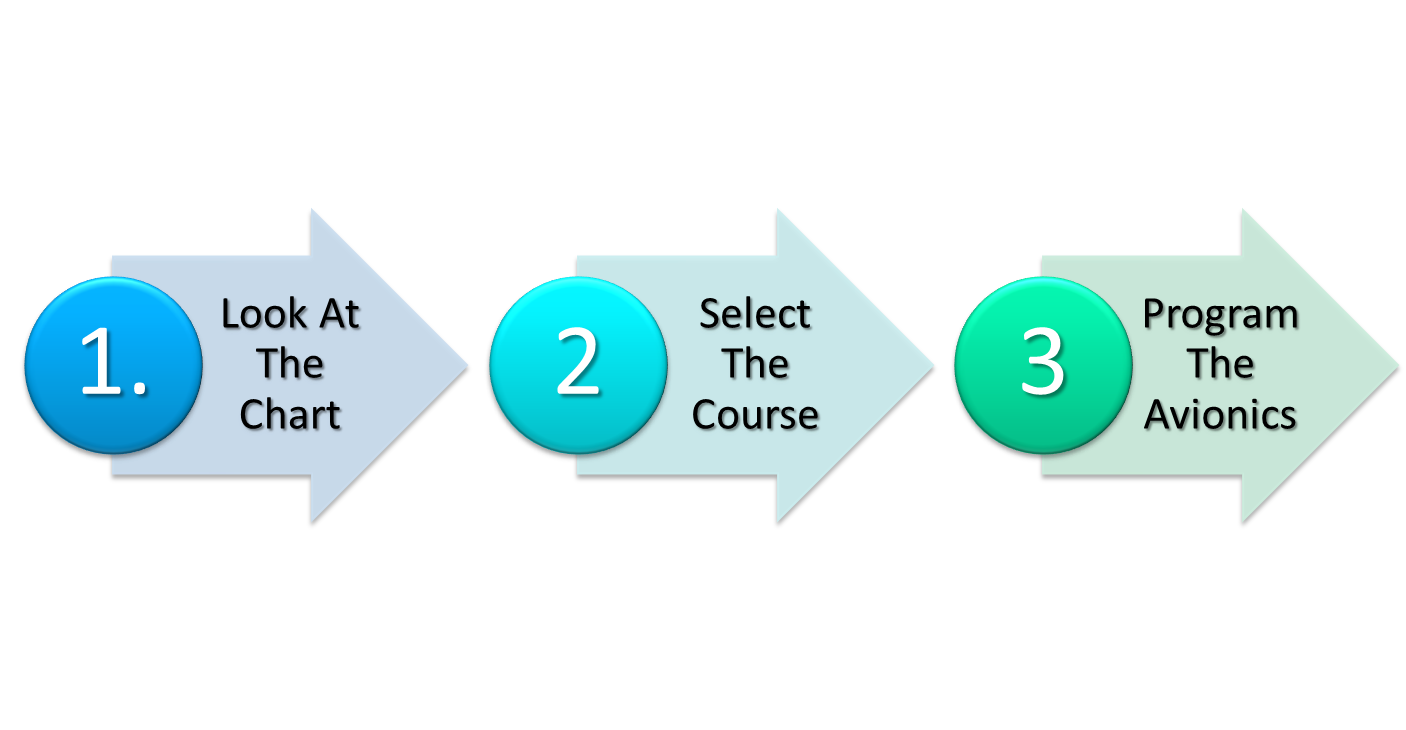
Look At The Chart
This simple action will make a profound improvement in your situational awareness. The mantra on the flight deck at MasterFlight is: Start With The Chart. When you look at the chart, you automatically build a mental model of where you are and what’s around you.
One of my favorite research studies, The Effect of GPS and Moving Map Displays on Navigational Awareness While Flying Under VFR, was performed by Dr. Stephen Casner (NASA Ames). After asking two groups of pilots to fly a rectangular course over terrain (one using sectional charts and pilotage and the other using GPSes and moving maps), he then asked those pilots to fly the same course again without any navigational aids, Dr. Casner found that pilots who had used GPSes and moving maps performed significantly worse than the pilots who had used sectionals and pilotage. Two of the automated pilots couldn’t even find the very first waypoint of the course.
Let’s practice Start With The Chart with the first set of ATC instructions:
“N12345, turn right Heading 070, intercept V25, resume own navigation.”
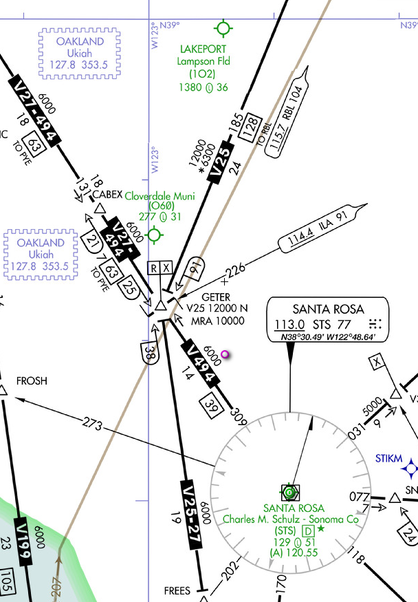 Click on the chart to the right to open it in another window. It shows us there could be a lot of interpretations to “intercept V25”. It depends on where we are, our assigned heading, and the ultimate direction we are going.
On the assigned heading, will we intercept V25 north or south of GETER? Once we intercept V25, will we be heading northbound or southbound along the airway?
The answers to these questions come from the chart. Here is where the use of an iPad really shines. Pilot apps are great tools for visualizing your current position on charts.
If we’ve departed Lakeport, CA on our way to Medford, OR and are north of GETER, we would intercept the Red Bluff (RBL) 185 radial northbound. If we’ve departed Santa Rosa on our way to Monterey, CA and somehow ended up southwest of GETER, we would intercept the Point Reyes (PYE) 335 radial and proceed southbound. The meaning of the instructions depends on the context we find ourselves in. You can’t just react to the words alone.
Select The Course
Figuring out which course to actually fly when assigned a radial or airway is like decoding a secret message. A particular course can be named many things, and you can’t predict what ATC will call it.
Let me draw an analogy. Back in the day, roads were named by townsfolk based on where the road took you.
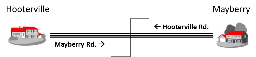
If you wanted to travel east from Hooterville to Mayberry, you would leave Hooterville on the Mayberry Rd., and arrive in Mayberry on the Hooterville Rd. Somewhere in the middle, the name would change—a changeover point as it were. But this naming scheme didn’t scale well.
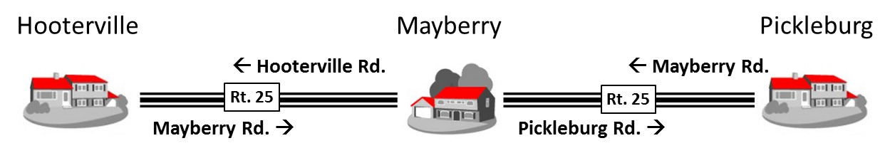
If I wanted to travel from Hooterville to Picklesburg by way of Mayberry, I’d start on Mayberry Rd., continue on Hooterville Rd. and Picklesburg Rd, only to come into Picklesburg on Mayberry Rd. It’s enough to drive you mad, and indeed, map makers and county road crews started to go nuts. The solution? Assign route numbers to a sequence of roads between towns. There are a lot of different routes: county roads, state routes, US highways, Interstates, but they all work the same. It is a name for multiple roads. Now to get from Hooterville to Pickleburg, you simply drive east on Rt. 25.
VORs, radials and airways work much the same way.
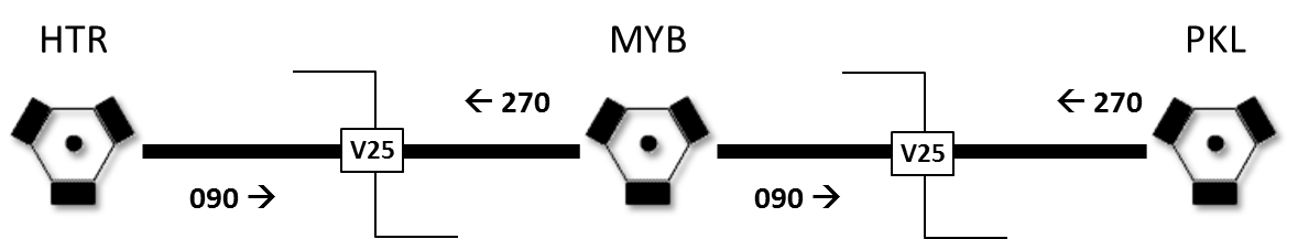
The main difference is that the names of the roads emanating from the VORs are directional. It’s almost as if you had uncreative townspeople thinking up the names. Instead of Mayberry Road, the folks in Hooterville called it East Road. “090 Radial” is another way to say “East Road.”
It is very useful for a pilot to think of radials as road names. That’s how ATC thinks about them. When ATC is telling you to intercept a radial, they are thinking in terms of named courses in the vicinity of a particular VOR. The direction to fly along that named course is another matter, and it is almost always implied.
Once you have the name of the road (the radial), you need to select the course along that road. Remember our friend looking for In-N-Out? He got on the right road, but turned the wrong way because we neglected to tell him which direction. The good news is you have a 50% chance of selecting the right course. The bad news is you have a 50% chance of selecting the wrong course.
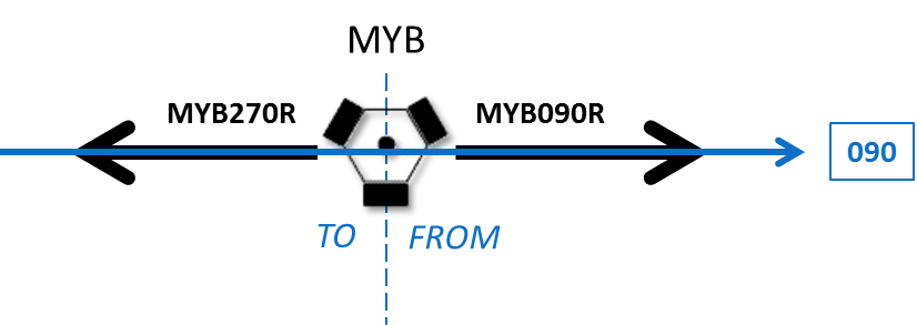
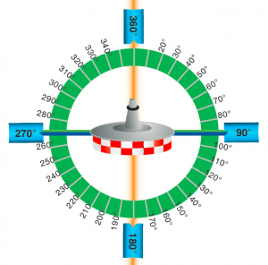
There is a direct relationship between radials and the courses you fly along the radials. The course to fly will either be the radial or its reciprocal. The figure above shows how an eastbound course (090) traverses two radials: the 270 radial TO the VOR and the 090 FROM the VOR. When flying toward the VOR, we are flying the reciprocal. When flying away from the VOR, we are flying the radial.
When you are instructed to fly along a radial, you need to figure out whether the course is indeed the radial or its reciprocal. There are a variety of tricks instrument instructors use. One is a memory aid based on whether you are flying TO or FROM the VOR:
“I love VORs FROM HEAD TO TAIL” or “I love VORs FROM TOP TO BOTTOM“
If are you flying FROM the VOR, you put the HEAD of the needle on the radial. If you are flying TO the VOR, you put the TAIL of the needle on the radial. When using a CDI flying FROM the VOR, you put the radial at the TOP of the CDI, and when flying TO the VOR, you put it at the BOTTOM of the CDI.
These tricks work for some people, but I am not a big fan of them because they are formulaic. In the absence of situational awareness, it is just as effective as flipping a coin. Instead, I would propose something simpler: choose your course from the radial or its reciprocal based on the overall direction you are flying.
For example, if you are flying generally east, and you have to choose between 270 and 090, the answer should be obvious, 090, because 090 is indeed east.
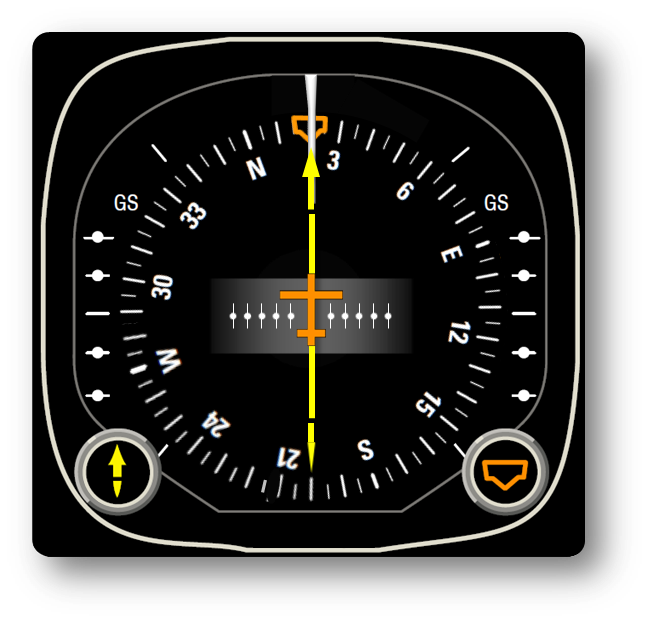
If you are instructed to intercept the 200 radial and you are flying generally northeast, then your course would be the reciprocal, 020.
You don’t have to do reciprocal math in your head. You can do it visually. It is obvious by looking at the HSI to the right that 200 is opposite to the direction you are flying. Therefore, you put the head of the needle on 020 (or the tail of the needle on 200).
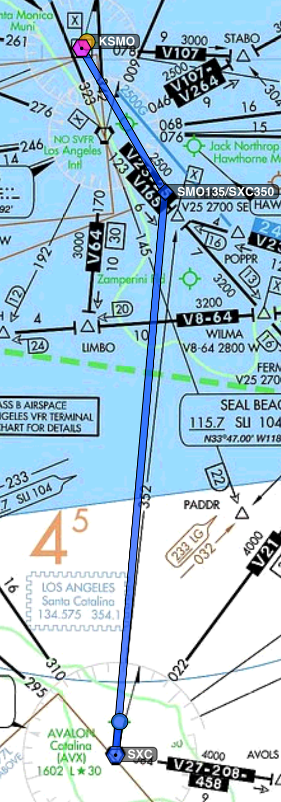
“N12345, amend route to: fly heading 080, intercept the Santa Monica 135 Radial, Santa Catalina 350 Radial, Santa Catalina. Rest of route unchanged.”
In this example, we are generally flying southeast and south from Santa Monica to Santa Catalina (click the picture on the left for a larger map). With that in mind, it should be obvious that our course from the Santa Monica VOR will be 135, and the course to the Santa Catalina VOR will be 170.
Program The Avionics
It’s only after you select the course to fly that you program the avionics. Don’t get sucked into the trap of trying to program the box before you actually understand what you want to accomplish. Programming the avionics is LAST.
To summarize, the procedure in response to ATC instructions to intercept (or hold along) an arbitrary course is:
- Look at the chart;
- Select the course; and only then
- Program the avionics.