
National Flight Instructor of the Year Jeffrey Robert Moss stumbled across a shortcoming of the G1000 VNAV implmentation during an arrival into Phoenix International airport. Imagine the avionics refusing to accept your descent altitudes! That’s what happened. Let’s break it down and understand why.
One of the basic tenets we hold here at MasterFlight is that there are gaps between the chart, the NavData, and the automation in the avionics. It is up to the pilot to actively manage the gaps, and often that requires some tweaking of instrument procedures once they are loaded into the active flight plan.
It’s also true that no two G1000 installations are the same. Aircraft manufacturers exert a certain amount of control over which G1000 features are included in their aircraft, and as a result, you may see different features and behavior as you transition from aircraft to aircraft. This issue with the KPHX EAGUL5 Arrival (pdf) was discovered inbound to Phoenix International in a Citation Mustang.

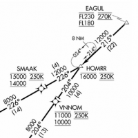
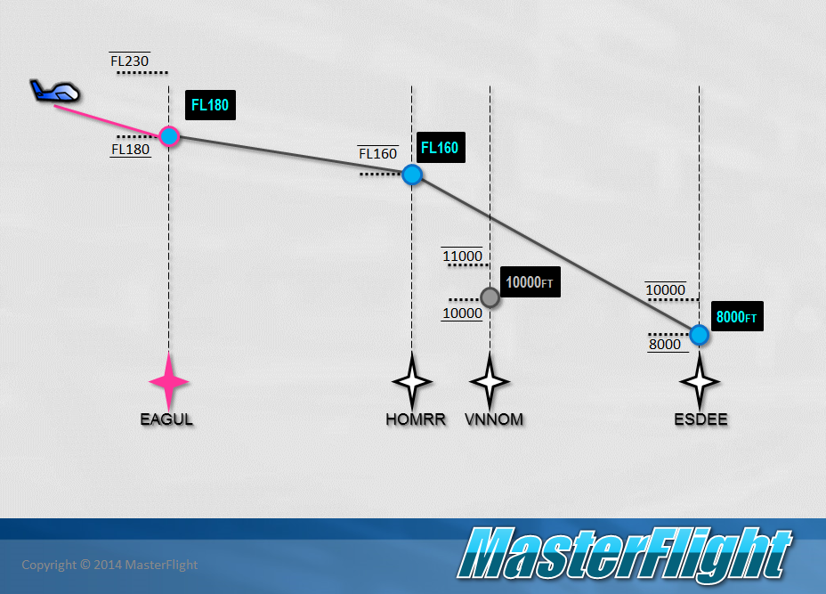
You will notice that the crossing restriction at EAGUL is at-or-below FL230 and at-or-above FL180, the crossing restriction at HOMRR is at-or-below 16000, and the subsequent crossing restriction at VNNOM is at-or-below 11000 and at-or-above 10000.
This is not unusual for a long Arrival Procedure for inbound jet traffic, and often a jet pilot flying at FL350 may get instructions to “descend via the EAGUL5 arrival” even though they are an entire state away. The pilot simply complies with the restrictions in the descent, and will find herself set up perfectly for the subsequent approach.
To manage the gaps and successfully fly the arrival, we need to understand (1) how the procedure is encoded in the NavData and (2) what the G1000 VNV automation will do to us (er, for us). To do that, I am going to rewind history back to the previous version of this arrival, the EAGUL4.
 Here is the EAGUL4 arrival as shown on a Cirrus Perspective. I was not able to locate the older version of the printed chart, but just by looking at the flight plan, we can see some of the altitude restrictions established for this version of the procedure.
The first altitude restriction in the NavData is at-or-below FL310 at TINIZ, followed by at-or-above FL250 at PAYSO, then at-or-above FL180 at EAGUL. There is no altitude restriction at HOMRR. Then at-or-above 10,000′ at VNNOM.
By default the Cirrus Perspective configuration puts the altitude restrictions in the flight plan as advisory VNV altitudes (they are white, not blue). If you were told to “descend via” this arrival, you would have to manually activate each appropriate altitude (turn it blue) by selecting it and pressing ENT.
I believe the reason for this is that Cirrus and Garmin expect a slower moving piston aircraft not to receive many “descend via” clearances. That would put it right in the path of descending jets. A Cirrus may be cleared for such an arrival, but would likely be assigned specific altitudes to keep it below the jets.
 This is what the EAGUL4 Arrival looks like on a Citation Mustang. The underlying NavData for the procedure is the same, but the behavior of the implementation is clearly different. Instead of populating the flight plan with advisory altitudes, it puts them in as active VNV waypoints (in blue). Notice that it picks a hard altitude for each of the restrictions. This is understandable because it is more likely a Citation Mustang descending out of the flight levels will get a “descend via” clearance, but THESE ALTITUDES MAY OR MAY NOT MAKE SENSE for your aircraft. This is a key point.
For example, the restriction is at-or-below FL310 at TINIZ, but the Mustang has converted that to a hard altitude crossing TINIZ at FL310. And it converts at-or-above FL250 at PAYSO to a hard FL250. These defaults are perhaps not a big deal for the EAGUL4 arrival. Most aircraft can lose 6,000′ in 20nm, but there are other situations where this simplification performed by the G1000 doesn’t work out.
Since there was no restriction at HOMRR, the G1000 calculates the altitude you will cross at and displays it in white. In other words, if you draw a straight-line vertical profile from EAGUL to VNNOM, that line will cross HOMRR at 11,300′.
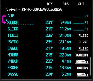 Here is the next version of the arrival, the EAGUL5 as shown on the Cirrus Perspective. The altitudes have changed, but the most significant difference is the addition of an altitude restriction at-or-below 16,000′ at HOMRR.
Now that we can compare the NavData to the chart (pdf) you can see some other interesting simplifications. For example, the charted restrictions at EAGUL are at-or-below FL230 and at-or-above FL180. However, the flight plan only shows the FL180 restriction. That’s because the G1000 can only display one VNV altitude, so it always picks the lower one. Again, that may or may not make sense.
Each time you load a procedure, any procedure, you must compare all the waypoints and VNV altitudes provided by the NavData, compare them against the chart, confirm they make sense for your flight, and if not, adjust them accordingly. For any number of reasons, you may want to cross at a higher altitude, if the restrictions allow it.
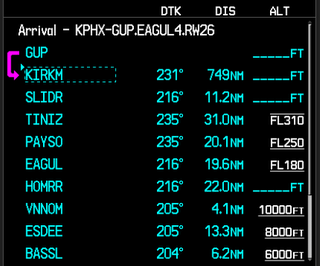
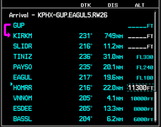
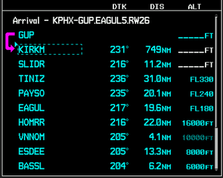 Now for the kicker. Here is the EAGUL5 arrival as displayed in the Citation Mustang. As before, the altitudes are populated with active (blue) VNV waypoints. But look at the altitude for VNNOM; it is grayed out. What is going on there?
What’s happening is the at-or-below 16,000′ restriction at HOMRR was turned into a hard crossing altitude, and to make the 10,000′ restriction at VNNOM, the aircraft would have to lose 6,000′ in 4.1nm. That’s simply not realistic, and the G1000 knows it. Any VNV altitude that is not achievable will be grayed out as inactive. So here we have an example where the simplifications imposed by the G1000 do not make actual sense for the flight.
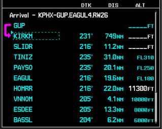
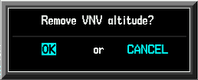
We need to adjust the flight plan to make it work. Must you cross HOMRR at 16,000′? No. The restriction is at-or-below. The fix is simple, change the altitude at HOMRR to something more reasonable for the descent, and the altitude at VNNOM will become active.
The simplest way to do that on the G1000 is to select the altitude at HOMRR, press the CLR key and confirm you want to remove the VNV altitude.
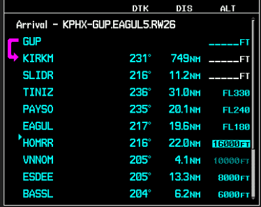
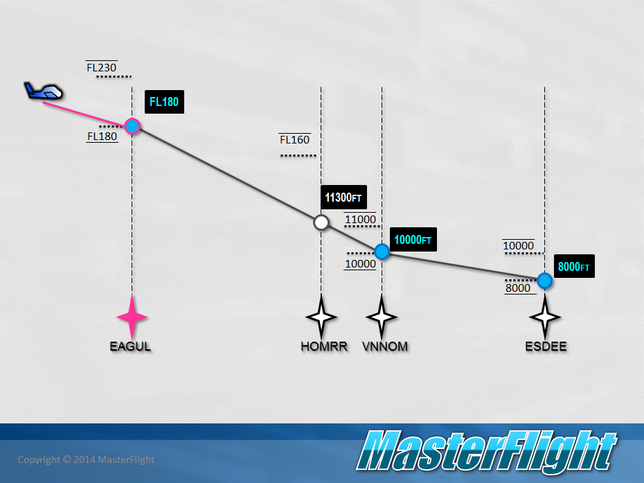
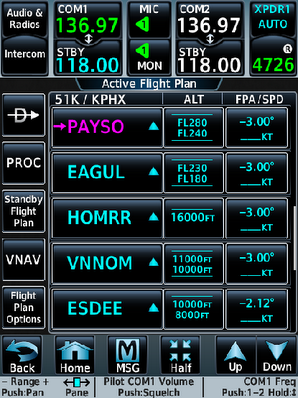
The G1000 now reverts to something that looks a lot like the EAGUL4 procedure and displays in white the altitude you will be at when you cross HOMRR. Does this makes sense? Yes, it does, because the calculated altitude of 11,300′ complies with the charted at-or-below 16,000′ restriction. In addition, you can see that the VNV altitude at VNNOM has become active.
The good news is that these kinds of issues will only diminish in the future as avionics become more and more capable. If you look at the VNV support in the G3000, it supports both altitude restrictions at a given waypoint and calculates a descent profile accordingly. Yipee.
So remember, after loading ANY instrument procedure in your flight plan:
- Review every waypoint and altitude.
- Determine what the automation will do to/for you.
- Decide whether it makes sense given the charted procedure.
- Make any necessary adjustments to the flight plan.
- Plan for any manual intervention you might need to make while flying the procedure (“choreograph your buttonology”).
That’s the MasterFlight way.